
Unmissable Seasonal Birding Trails for Spectacular Migratory Bird Watching
By Erick Updated 12 min read
As an Amazon Associate I earn from qualifying purchases. That costs you nothing and does not decide what gets recommended. We also earn a commission from some links to partner brands (POPOSOAP).
On this page (9 sections)
- The Month-by-Month Migration Calendar for Arizona
- Top 5 Unmissable Trails for Spring Migration (March–May)
- Prime Fall Migration Routes (August–October)
- Winter Waterfowl and Crane Hotspots (November–February)
- Essential Gear and Camera Settings for Trail Birding
- How to Bird Ethically: The Unwritten Rules of the Trail
- Real-Time Tracking: Using eBird and BirdCast to Plan Your Trip
- Frequently Asked Questions on Seasonal Arizona Birding
- Three Common Mistakes (and How to Avoid Them)
You’ve been there. You wake up before dawn, drive an hour to a “hotspot” you found online, and walk for three hours seeing nothing but house sparrows and a single crow. The warbler you wanted? It left two weeks ago. The crane flock? They shifted to a different field because the corn got harvested early. Sound familiar?
This guide fixes that. You’ll get exact trail names, trailhead GPS coordinates, difficulty ratings, and a month-by-month calendar for Arizona’s best migratory bird watching. No vague “check local hotspots” advice. You’ll know where to stand, when to be there, and what gear actually helps (spoiler: a good compact binocular beats a heavy scope on most of these trails). You’ll also learn how to read real-time migration data so you never chase birds that aren’t there.
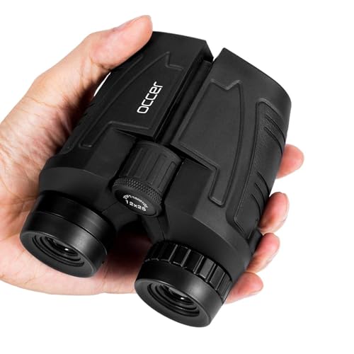
occer
Occer 12x25 Compact Binoculars for Adults and…
- 【HIGH-POWERED LARGE EYEPIECE BINOCULARS】 This binoculars for adults has 12x magnification, 25mm objective lens and wide field of v…
- 【ADJUSTABLE EYE CUPS FIT EYEGLASS WEARERS OR NOT】The binocs can be pull down the rubber eyepieces and more fit the glasses wearer,…
- 【FMC BROADBAND COATING TECHNOLOGY】The lightweight cruise binoculars is cover with BAK4 prism texture. The objective lens use optic…
One piece of gear advice before we start: on trails like these, you’ll want something you can grab quickly without fumbling. The Occer 12×25 compact binoculars are light enough to hang around your neck all day, and the 12x magnification gets you close enough to see the eye stripe on a Wilson’s warbler. They’re not a substitute for a full-size optic, but they’re the kind you’ll actually carry on every hike.

The Month-by-Month Migration Calendar for Arizona
Arizona sits at the crossroads of four major flyways. That means something rare passes through almost every week of the year. But the real action clusters into three windows.
- Spring migration (March 15 – May 10): Warblers, vireos, tanagers, and flycatchers pour through southeastern Arizona’s Sky Islands. Peak warbler diversity hits the third week of April. Hummingbirds arrive in numbers by mid-April.
- Fall migration (August 15 – October 20): Southbound birds move in broader, less predictable waves. Young birds wander more, which means rarities show up in unexpected places. September is the best month for sheer variety.
- Winter waterfowl and cranes (November 15 – February 20): Sandhill cranes peak in late December and early January. Over 40,000 cranes winter in the Sulphur Springs Valley, along with geese, ducks, and bald eagles.
- Shutter speed: 1/1000s minimum for perched birds. 1/2000s for flight shots.
- Aperture: f/5.6 to f/8 for a single bird. f/8 to f/11 for flocks.
- ISO: Start at 400 in bright sun. Don’t be afraid to push to 1600 — modern cameras handle noise well.
- Focus mode: Use back-button focus or single-point AF. Center-point is fastest for birds in branches.
- Keep your distance from nests. If a bird is agitated, fluttering, or giving alarm calls, you’re too close. Back away slowly.
- Don’t use playback (recorded bird calls) for rare species. It stresses the bird and can cause it to abandon its territory. For common species, use it sparingly.
- Stay on designated trails. Off-trail walking crushes nesting habitat and disturbs ground-nesting birds.
- Don’t feed birds. It changes their natural foraging behavior and can spread disease.
- Report your sightings on eBird. This helps researchers track populations. But for sensitive species (like owls), use the “hide” feature.
- eBird (ebird.org): Check the “Explore” tab and look at recent sightings for specific hotspots. The bar charts show which species are likely in a given week. Filter by date and location to see what’s been reported in the last 7 days.
- BirdCast (birdcast.info): This uses weather radar to show live migration intensity. Check the “Migration Dashboard” for your region. If it shows a high-migration night, the next morning will be excellent for finding new arrivals.
- ABA Rare Bird Alert: Subscribe to the American Birding Association’s rare bird alerts for Arizona. You’ll get emails when a vagrant shows up — that’s how you find the once-in-a-decade bird.
- Birding at the wrong time of day. The midday lull is real. Birds are silent and hidden from 10 AM to 4 PM. Plan to be on the trail at first light and again in the last two hours of daylight. Use the middle of the day to drive between spots, eat lunch, and check eBird.
- Walking too fast and too far. The birder who covers 5 miles in a morning sees fewer species than the one who covers 1 mile slowly. Stop often. Sit on a bench for 10 minutes. Watch the same tree for a while. The birds will come to you.
- Ignoring the weather. A cold front or rain system can ground migrants for days — which is great for birding. But a strong wind or heat wave can push birds out or make them invisible. Check the forecast before you go. If it’s windy, bird the sheltered canyons. If it’s just rained, the birds will be foraging actively along the edges.
Here’s the trap: people plan around “spring” as one block. But a bird that arrives March 20 might be gone by April 5. If you want a specific species, you need a specific week. The calendar below gives you those windows.
| Species Group | Peak Window | Best Trail | Time of Day |
|---|---|---|---|
| Warblers (e.g., Grace’s, Black-throated Gray) | April 15 – May 5 | Chiricahua Mountain Loop | Dawn to 9:00 AM |
| Hummingbirds (e.g., White-eared, Blue-throated) | April 10 – May 20 | Patagonia-Sonoita Creek Preserve | 7:00 – 10:00 AM |
| Sandhill Cranes | December 20 – January 15 | Willcox Playa (viewing platform) | Sunrise and sunset |
| Flycatchers (e.g., Dusky-capped, Sulphur-bellied) | May 1 – May 30 | Ramsey Canyon Vista Trail | Morning |
| Waterfowl (ducks, geese, grebes) | December – February | San Pedro Riparian Trail | Late afternoon |
Top 5 Unmissable Trails for Spring Migration (March–May)
These aren’t just good spots. They’re reliable. Each one has a distinct habitat that pulls in different species. Pick based on what you want to see, not just what’s closest.
The Chiricahua Mountain Loop (Difficulty: Moderate)
Trailhead GPS: 31.9239° N, 109.2784° W (South Fork Trailhead, Cave Creek Canyon).
Distance: 4.2 miles round trip.
Elevation gain: 800 feet.
This is the crown jewel of southeastern Arizona birding. The trail follows Cave Creek through sycamore and pine forest, and the riparian corridor acts like a funnel for migrating songbirds. In late April, you can tick 15 warbler species in a single morning. The key is to start at first light and walk slowly — 1 mile per hour is not too slow.
Pro tip: the bridge crossing at mile 1.3 is a natural bottleneck. Stand there for 20 minutes and let the birds come to you. Don’t chase every chip note.
One honest caveat: the last half mile climbs steeply. If you’re not used to elevation (6,000 feet here), take breaks. The best birding is actually in the first two miles anyway.
Patagonia-Sonoita Creek Preserve Boardwalk (Accessible)
Trailhead GPS: 31.5268° N, 110.7715° W (Preserve entrance off Blue Heaven Road).
Distance: 1.5 miles of flat, packed gravel and boardwalk.
Accessibility: Wheelchair-friendly. Benches every 200 yards.
This is the easiest high-quality birding in Arizona. The cottonwood-willow riparian forest here is one of the last remaining in the state, and it’s a magnet for Gray Hawks, Vermilion Flycatchers, and Rose-throated Becards (rare but regular). The boardwalk runs along the creek, so you get eye-level views of birds bathing and foraging.
Bring your camera. The birds here are habituated to people and will let you approach within 30 feet. A 300mm lens is enough; you don’t need a 600mm monster.
Pro tip: the preserve opens at 8:00 AM, not dawn. Arrive at 7:45 to be first in line — the first hour is dramatically better than the rest of the day.
Madera Canyon Nature Trail (Difficulty: Easy)
Trailhead GPS: 31.7258° N, 110.8800° W (Proctor Road parking area).
Distance: 2.3 miles out and back.
Elevation gain: 300 feet.
Madera Canyon is famous for its feeders — the Santa Rita Lodge feeders attract 14 hummingbird species in April. But the Nature Trail behind the lodge gets you away from the crowds. Look for Elegant Trogons along the creek, and keep an eye on the oak slopes for Black-throated Gray Warblers.
Pro tip: the trogon nests in sycamore cavities near the trail. If you see a pair of birders staring at a hole in a tree, that’s why. Join them quietly.
Carr Canyon Trail (Difficulty: Strenuous)
Trailhead GPS: 31.4456° N, 110.2978° W (Carr Canyon Road end).
Distance: 5.1 miles round trip.
Elevation gain: 1,600 feet.
This one’s for the fit birder. The switchbacks climb through oak woodland, then pine forest, then into the Huachuca Mountains proper. You’ll work for your birds, but the payoff is species you won’t see elsewhere: Buff-breasted Flycatchers, Red-faced Warblers, and the occasional Spotted Owl near the top.
Go mid-week. The road to the trailhead is rough — high clearance helps. And check the weather; afternoon thunderstorms roll in almost daily in July and August.
Miller Canyon Trail (Difficulty: Moderate)
Trailhead GPS: 31.4164° N, 110.2753° W (Beatty’s Guest Ranch parking).
Distance: 3.4 miles round trip.
Elevation gain: 900 feet.
The Beatty’s feeder area at the bottom is famous for the rare (and now possibly extirpated) Berylline Hummingbird. But the trail itself is better for warblers and thrushes. The upper section passes through a fire-scarred area that’s regenerating — great for woodpeckers and flycatchers.
Pro tip: there’s a reliable pair of Zone-tailed Hawks that patrol the ridgeline around 9:00 AM. They look like vultures until they turn — that’s the trick.
Prime Fall Migration Routes (August–October)
Fall is different. Birds aren’t singing — they’re feeding silently. You’ll need to watch for movement and listen for soft call notes. The trails below are the most productive during this window.
The San Pedro Riparian Trail (Difficulty: Easy)
Trailhead GPS: 31.5608° N, 110.1371° W (San Pedro House, Sierra Vista).
Distance: 6 miles out and back, or do as much as you want.
Elevation gain: Flat.
The San Pedro River is the last undammed river in Arizona, and its riparian corridor is a major stopover for fall migrants. In September, you’ll see Willow Flycatchers, Bell’s Vireos, and dozens of warbler species. The trail is wide, flat, and easy to walk while scanning both sides.
Pro tip: check the mesquite thickets near the river bends. Fall migrants hide there to avoid predators. You’ll often flush a group of 20 birds at once — stand still and they’ll resettle nearby.
Ramsey Canyon Vista Trail (Difficulty: Strenuous)
Trailhead GPS: 31.4440° N, 110.3090° W (Ramsey Canyon Preserve parking lot).
Distance: 4.8 miles round trip.
Elevation gain: 1,400 feet.
This trail climbs steeply from the canyon floor to a ridgeline viewpoint. The lower section has good fall warbler action, but the real prize is at the top: the vista offers a hawk-watching platform where you can watch Broad-winged Hawks and Swainson’s Hawks kettle and stream south in October.
Bring water — at least 2 liters. The trail is exposed for the last mile, and even October sun is intense at this elevation.
Whitewater Draw Wildlife Area (Easy, but not a trail)
Viewing platform GPS: 31.2686° N, 109.6870° W.
Distance: Short walks from parking lot.
This is the fall staging ground for sandhill cranes before they settle into winter grounds. From mid-October, you’ll see flocks of 5,000+ cranes coming in at sunset. The cacophony is unforgettable — a rolling, bugling wall of sound.
Pro tip: arrive 90 minutes before sunset. The cranes fly in from surrounding fields in waves, and the last wave is the biggest.
Winter Waterfowl and Crane Hotspots (November–February)
Winter birding in Arizona is underrated. The cranes are the headline, but the waterfowl diversity on the state’s reservoirs and playas is genuinely impressive.
Willcox Playa (viewing from the Amerind Museum overlook): 32.0110° N, 109.5780° W. This is the main crane roost. Best at sunrise when the cranes lift off in waves, or at sunset when they come back. Bring a scope if you have one — the birds are often 300+ yards out.
Lake Roberts (near Silver City, NM): 33.0300° N, 108.1300° W. A 90-minute drive from the Arizona border, but worth it for Canvasback, Ring-necked Duck, and Common Merganser. The lakeside trail is flat and easy.
Gilbert Water Ranch (Phoenix metro): 33.3550° N, 111.7310° W. Not technically a trail, but the pond circuit is 1.2 miles of paved path. In December, you’ll see Green-winged Teal, Northern Shovelers, and the occasional rarity like a Cinnamon Teal x Blue-winged Teal hybrid.
Pro tip: waterfowl are most active in the last two hours of daylight. Don’t bother going at noon — the birds are resting and invisible.
Essential Gear and Camera Settings for Trail Birding
You don’t need a full camera kit to enjoy these trails. But if you want photos, here’s what works.
Binoculars
This is the one piece of gear you’ll use every single minute. A good pair makes the difference between seeing a bird’s field marks and just seeing “a small brown bird.” The Occer 12×25 compact binoculars I mentioned earlier are a solid pick for these trails. They’re small enough to keep in a jacket pocket, and the 12x magnification gives you more reach than the typical 8x or 10x. The adjustable eyecups work well if you wear glasses — you just twist them down. One honest note: the 25mm objective lens means they’re not great in low light. For dawn birding, you’ll want a larger objective lens (like 42mm). But for the bright Arizona sun, these are perfect.
Camera Settings
Pro tip: set your camera to burst mode (10 fps or higher) and take 3-5 shots per bird. The difference between a sharp wing and a blurry one is often a fraction of a second.
Blind Placement
If you’re serious about photography, setting up a portable blind near a water source is the most effective technique. Position it 20-30 feet from the water’s edge, with the sun behind you. Arrive 30 minutes before the birds do. For more on this, see this bird hide setup guide.
How to Bird Ethically: The Unwritten Rules of the Trail
Birding ethics aren’t optional. They protect the birds, and they keep trails open for everyone.
Pro tip: if you see a photographer baiting an owl with a live mouse, report it to the local wildlife agency. That’s not birding, it’s harassment.
Real-Time Tracking: Using eBird and BirdCast to Plan Your Trip
You can’t rely on last year’s blog posts. Bird movements shift with weather, food availability, and habitat conditions. Use these tools to know what’s happening right now.
Pro tip: combine these. On Friday night, check BirdCast for migration intensity. If it’s high, plan to hit your target trail Saturday at dawn. Then check eBird for the last 3 days of sightings to confirm the target species is still present.
Frequently Asked Questions on Seasonal Arizona Birding
When is the absolute best week for birding in southeastern Arizona?
The last two weeks of April (April 15-30). This window captures the peak of warbler migration, the arrival of most hummingbird species, and the beginning of flycatcher nesting. It’s crowded, but the diversity is unmatched. If you can only do one trip, make it those two weeks.
Are these trails safe for solo birders?
Yes, with caveats. The accessible trails (Patagonia-Sonoita, San Pedro, Whitewater Draw) are safe year-round. The strenuous mountain trails (Carr Canyon, Ramsey Canyon) are safe in good weather, but you should tell someone your route and carry a charged phone. Cell coverage is spotty in the canyons. Bring at least 2 liters of water, even in spring.
What’s the difference between the Sky Islands and the rest of Arizona?
The Sky Islands are isolated mountain ranges in southeastern Arizona (Chiricahua, Huachuca, Santa Rita, etc.) that rise from the desert floor. Their elevation creates distinct life zones — desert, grassland, oak woodland, pine forest — in a short vertical distance. That compression means you can see 100+ species in a single day by driving from the base to the top of one mountain. It’s the most productive birding region in the United States.
Do I need a guide for these trails?
No, but it helps. The trails are well-marked and the birds are abundant. But a local guide knows the exact territories, the best time of day for each species, and the current status of rarities. If it’s your first trip, consider hiring a guide for one day to learn the ropes, then go out on your own. Several excellent guides operate out of Sierra Vista and Portal.
Can I bird these trails with kids or older adults?
Yes, if you pick the right trails. Patagonia-Sonoita Creek and the San Pedro Riparian Trail are flat, short, and rewarding. The Willcox Playa viewing platform is accessible by car. Skip the strenuous mountain trails unless everyone in the group is fit. For more accessible options, check out this guide to Florida birding trails — many of those are similarly easy.
Three Common Mistakes (and How to Avoid Them)
You’ve got the calendar, the trails, and the gear. Now here’s what trips people up.
One last thing: carry a field notebook or use the notes app on your phone. Write down what you see, the time, and the habitat. You’ll build a personal record that makes your next trip better. And if you’re planning a longer trip, consider the long-distance birding trails guide for when you’re ready to push beyond the day hikes.
Now get out there. The birds aren’t waiting.